Facilities
Physical Facilities
The administrative unit and the majority of research office space are located in the 1100 wing of Girvetz Hall. NEES program personnel occupy the adjacent 1200 wing of Girvetz Hall. The ICS Research Lab located in the Arts building houses the astrobiology program and the seismological instrumentation laboratories.
Institute for Crustal Studies
Mail Code 1100,1140 Girvetz Hall
UC Santa Barbara, Santa Barbara, CA 93106-1100
Voice: (805) 893-8231, FAX: (805) 893-8649
web: http://www.crustal.ucsb.edu
ICS Departmental Computing Systems and Services
General Computing Services Description
Computing resources at the Institute are geared towards supporting a variety of research projects. In the past this consisted primarily of geophysics and seismology research, but the increasing number of interdisciplinary research projects have broadened the scope of the resources provided at the Institute. Sofware packages available include several major seismic processing packages, GIS and geographical analysis software as well as mathematic analysis software to meet the increasingly mathematically intensive research. Centralized servers provide access to email, web (WWW), FTP , NFS and SMB services.
The Institute's LAN supports over 100 devices, including servers, workstations, desktop machines, laptops, printers and other network based devices. Operating systems supported are split roughly equally between Solaris, Mac OS and Windows. The majority of the solaris boxes are at version 9. Macintosh systems are now running either OSX-10.3.x (Panther) or OSX-10.4 (Tiger). Windows boxes are running a variety of flavors of windows, including XP, NT, 2000. Most of the Unix machines have in excess of 100Mb of main memory, including a few of the newer unix boxes that have 2Gb or more of main memory allowing them to be used for larger number crunching jobs. Hard disk storage for the solaris boxes at the institute is 4.0Tb and is at about 30% usage. About one third of this storage is accounted for between 3 large RAID systems that are used to support the Unix workstations.
Crustal Studies maintains several workstations designed for specific tasks, such as graphics, GIS, scientific visualization and seismic processing.
General Network Services Description
The Crustal Studies LAN is connected via fiber to the UCSB campus next generation backbone (NGB). The incoming link is a 1000SX FDx (Full Duplex) fiber link that connects directly to our high speed, managed, layer 2 switch with 10/100/1000BaseT auto-sensing ports. Another managed switch with 10/100BaseT auto-sensing ports is connected to this primary switch through 4 aggregated 100BaseT FDx links. The vast majority of computers at the institute are connected directly to one of the cascaded layer 2 switches. The ICS network has been extended to several remote locations via VLAN tagging across the campus backbone: Webb Hall (Geological Sciences), Girvetz 1205 (NEES project) wing, and the ICS Research Lab in the Arts building.
Other Computing Services Description
The institute has a variety of network printers available to users. Along with high speed color and monochrome laserwriters, the Institute has several inkjet printers including a 36" wide, 300dpi color inkjet printer. The institute also has a lightweight, high contrast, DLP projector that works with both Macintosh and Windows Systems.
ICS Researchers will soon have access to a new level of local computing power through the acquisition of a Western Scientific 32 node (64 CPUs) compute cluster.
Other computing resources include an six CPU Sun Enterprise 3500 compute server with 6Gb of main memory obtained for an interdisciplinary project with physics. This SMP computing box is available to ICS researchers.
Several unix and mac workstations are available to visitors and students in a centralized work area.
Data Centers
Consortium of Organizations for Strong-Motion Observation Systems (COSMOS) Data Center
The COSMOS Virtual Data Center (VDC) is an unrestricted web-based search engine for access to worldwide earthquake strong-motion data. It provides an interactive resource for research and practicing earthquake engineers, earth scientists, and government and emergency response professionals. VDC users have a wide range of access options; they may search on specific characteristics of the data, view data in a geographical perspective, preview records, compare recorded data with design spectra and retrieve the data and metadata of most interest to them.
The VDC continues to expand and improve the accessibility of strong-motion records worldwide. In the last few years substantial data sets representing earthquakes with magnitude > 5.0 have been added: ChiChi, Taiwan; all New Zealand records from 1966-1999; the Guerrero array on the Pacific Coast of Mexico, as well as smaller but seismically important data sets from Central Asia, Turkey and India. This last year, notable additions were earthquakes in Parkfield and Obsidian Butte, CA, Dillon MT, Niigata and Hokkaido, Japan. The data available through the VDC now includes 511 earthquakes, more than 3,000 stations, and more than 26,000 individual station records. These station records all include acceleration, and most include velocity, displacement and spectra files, as well as metadata about site geology and instrumentation. Improvements for users include streamlining the download process and site navigation.
The VDC is affiliated with COSMOS, the Consortium of Organizations for Strong-Motion Observation Systems, a public-interest nonprofit corporation of federal and state agencies, universities and private companies. COSMOS' mission is to expand and modernize the acquisition and application of strong-motion data in order to increase public earthquake safety. The VDC is supported by funds from the National Science Foundation (CMS-0201264), COSMOS, the USGS and the CGS; and COSMOS also provides a working group which oversees the operation and development of the VDC.
Instrumentation and Seismic Observatories Programs at ICS
Portable Broadband Instrument Center
Background
The Portable Broadband Instrument Center (PBIC) was established in 1991 by the Southern California Earthquake Center (SCEC) to provide researchers with year-round access to a "pool" of high-resolution, digital seismic recording equipment. The PBIC is managed out of ICS by Principal Investigator Jamie Steidl.
The data recorders maintained by the PBIC are Refraction Technology (RefTek) 16 and 24 bit data acquisition systems (DAS's). Sensors consist of high output short period velocity transducers to record very small ground motion, force balance accelerometers designed to stay on-scale (up to +-2G) for the strong ground motion expected from very large earthquakes, and intermediate period weak motion sensors that provide increased frequency bandwidth to allow better investigation of deep basins and teleseismic or global earthquake monitoring. A broad dynamic range of recording is obtained by pairing both weak motion and strong motion sensors with a single recorder.
Highlights of the past year
Two new experiments were conducted within the 2004/2005 year using PBIC equipment. The first experiment was the USGS coordinated Parkfield aftershock deployment where PBIC instruments were co-located at strong motion stations to record empirical Green's functions for use in analysis of the mainshock and for site response studies. The second experiment was a Caltech managed deployment within the Broad Center building on the Caltech campus. Data from ambient noise monitoring and active shaking on campus was collected and analyzed as part of a students Ph.D. thesis project.
In addition to the two experiments in the last year, the normal maintenance of the equipment was preformed, including replacing the internal batteries on all power supply and CPU boards within each DAS. Three undergraduate students participated in the PBIC activities this past year, and one new student has begun working this summer. We have also just recently been approved to receive a pallet of DAS's and associated hardware from the IRIS Passcal instrument center, that will eventually be managed by the SCEC PBIC.
This used equipment is the RefTek 72A-08 series and matches the existing PBIC equipment. As seen in the recent San Simeon and Parkfield aftershock deployments this older data acquisition technology does continue to perform well. With this addition to the PBIC, we should be better prepared for any potential post-earthquake rapid deployment in southern California, with our total number of working stations back to around twenty or more. Given the level of recent seismic activity in southern California, this is a timely development.
A significant part of the research efforts at ICS are centered around understanding the physics of the earthquake process and the effects of earthquakes on the built environment. These require not only computational facilities for doing theoretical modeling of wave propagation and earthquake source process simulation, but also field observatories for monitoring earthquake activity. These field observatories provide the control data for testing our theoretical models and simulation techniques, so we can determine if our models are matching real observations of earthquakes.
ICS operates a number of field facilities for monitoring earthquakes. The cost of installing and operating both portable instrumentation and permanent field sites can be quite high, so these costs are shared by many funding agencies. Currently, the largest field monitoring program at ICS is supported through the National Science Foundation (NSF) Engineering Directorate's George E. Brown Jr., Network for Earthquake Engineering Simulation (NEES) program. Support from NSF's Earth Sciences directorate and the U.S. Geological Survey through the Southern California Earthquake Center provide support for the Portable Broadband Instrument Center (PBIC) and the Borehole Instrumentation Program. These combined resources as well as some local institutional resources and in-kind support from other agencies are used to maintain the overall instrumentation and seismic observatories program at ICS.
NEES@UCSB
The NEES @UCSB program, "Permanently Instrumented Field Sites for Soil-Foundation-Structure Interaction (SFSI)", one of 15 experimental earthquake engineering facilities in the U.S., is a 10-year operation to monitor earthquake activity at two field sites in Southern California as well as to facilitate active experimentation at these sites over the decade long program. The overall goal of the NEES program is to accelerate progress in earthquake engineering research and to improve the seismic design and performance of civil and mechanical infrastructure systems through the integration of people, ideas, and tools in a collaboratory environment. The NEES@UCSB field sites are integrated with the other 14 experimental facilities through central data and computational services via a unique IT infrastructure.
The overarching goal of the NEES@UCSB field site program is to improve on our ability to generate analytical and empirical models for accurate simulation of how the ground responds and deforms when shaken by earthquakes and to understand how this seismically induced shaking affects building structures and foundations. Two complimentary approaches have been developed: intensive monitoring of natural earthquakes with down-hole seismometers and pore pressure transducers, and the use of large "mobile shakers" to allow active shaking of both structures and the nearby ground during controlled experiments.
The Garner Valley NEES site:
Over the past two years, the original Garner Valley Downhole Array (GVDA) site has undergone a significant "face-lift" and expansion in scope with it's integration into the NEES program. The Garner Valley downhole array (GVDA) project was originally installed under funding from the U.S. Nuclear Regulatory Commission in cooperation with the French Commissariat a l'Energie Atomique (CEA). The GVDA site was initially constructed to understand the effects of the near-surface soil conditions on seismic ground motion to improve ground motion prediction capabilities for design, seismic hazard assessment, and hazard mitigation. It was then expanded to understand the effect of earthquake ground motion on the hydraulic conductivity of ground water systems for the deep storage of nuclear waste. Now, with the complete integration into the NEES program the focus has expanded in scope to include issues like soil-foundation-structure interaction and liquefaction. A reconfigurable, steel-framed structure has been constructed at the GVDA site and instrumented with sensors in the structure, foundation, and underlying soil to monitor both earthquake activity and active shaking at the site.
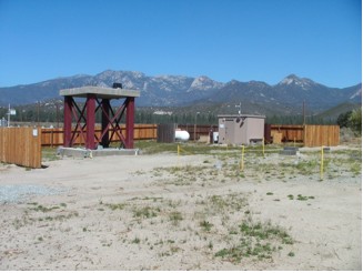
The NEES Garner Valley Array Facility
The near-surface geological site conditions have been shown to be the dominant factor in controlling the amplitude and variation of strong ground motion, and the damage patterns that result from large earthquakes. This unique set of data collected from the Garner Valley project should help to advance the field of engineering seismology and geotechnical earthquake engineering. Problems such as how weak motion scales to strong motion, and how the recordings at different soil types scale to each other, especially with respect to a competent rock ("reference") site. The understanding of competing effects of amplification and attenuation including soil non-linearity and the extreme case of liquefaction is of a vital importance for seismic design studies. The site is located near the Anza segment of the seismically active San Jacinto fault in Southern California, which has a relatively high probability for a large earthquake of magnitude 6.5 or greater in the near future. The new instrumentation and revitalization of the facilities at Garner Valley from the integration into the NSF NEES program will provide a unique high quality data set that will be the subject of many research studies in the future.
The NEES Wildlife Liquefaction Array field site:
A completely new site was developed under the NEES@UCSB program in the Imperial Valley of Southern California, just below the Salton Sea. The site, is located on California's Imperial Wildlife Management game refuge, was the site of an array installation in the early 1980's by the U.S. Geological Survey. This site was recently instrumented under the NEES program because of its history of significant ground shaking earthquakes in the region, six of which have generated liquefaction effects within 10 km of the site in the last 75 years. All of the pore pressure transducers installed in the early 1980's to monitor soil liquefaction behavior have since failed. The new installation, located 65 meters down river from the previous site, has now been recording local earthquakes for the past year and also has been a test site for active shaking by one of the NEES mobile shakers. In addition, funding was obtained within the last year to re-instrument the old site and connect it in with the new site.
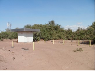
The NEES Wildlife Liquefaction Array Facility
The location of this permanent field site within the highly active seismic region that includes the Southern end of the San Andreas Fault should provide a wealth of data in the next 10 years of operation. In addition, this section of the fault system has not ruptured in over 300 years and is considered to be "overdue" so the site is well situated to capture the next "big one" on the San Andreas. As a supplement to the data from local earthquakes, active field tests like the one conducted this past year using the NEES mobile shaker "T-Rex" (operated by University of Texas at Austin) are also helping to advance our goals of better understanding soil response and pore pressure generation during strong shaking.
UCSB Operated Observatories
In addition to the NEES facilities, two other engineering seismology array facilities donated to UCSB by the Japanese are currently operated using ICS resources. These arrays are very similar in scope to the NEES observatories. One is located in Southern California near Borrego Springs and the other is located in Central California, near the towns of Salinas and Hollister. These additional arrays provide greater chances for catching a big earthquake in close at a densely instrumented site as they are also located in seismically active areas.
The Borrego Valley Downhole Array:
In 1993, Kajima Engineering and Construction Corp. and Agbabian Associates established the Borrego Valley downhole array (BVDA) near Borrego Springs, in Southern California. In this array there are four borehole instruments extending depths of 9, 19, 139 and 238 m. In addition, BVDA has 15 surface instruments extending in two directions across the Borrego Valley, and a remote rock site at the edge of the valley that includes surface and borehole sensors. At the main station data acquisition systems building the shear wave velocity gently increases from about 300 m/s at the surface to 750 m/s at 230 m-the granite interface-where it jumps to 2500 m/s. The water table is at ~92 m; BVDA is representative of a dry site in NEHRP site class C.
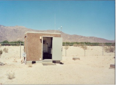
The UCSB Borrego Downhole Array Facility
The BVDA site is complementary to the NEES facilities in that it represents a different soil condition (dry vs. wet) and slightly stiffer material properties. It is important to collect data from all of the soil conditions encountered in the built environment if we want to test our simulation methods using different soil models.
The Hollister Earthquake Observatory:
Agbabian Associates installed the Hollister Earthquake Observatory (HEO) in 1991 with funding from the Kajima Engineering and Construction Corp. Kajima Corp donated this array to the University of California, Santa Barbara in January 1998. It is located in the Salinas Valley where alluvium overlies Tertiary sandstone overlying Granitic basement. HEO has been operating since early 1992, and is located about 10 kilometers from the San Andreas fault near the cities of Hollister and Salinas in central California. The ground motion array consists of a vertical array of six accelerometers in Quaternary alluvium, and three accelerometers installed at a remote rock station, 3 km to the Northeast. At the HEO main soil station accelerometers are located at 192, 110, 50, 20, 10, and 0 meters depth, going from crystalline rock at the bottom, up through consolidated and unconsolidated alluvium to the surface. Three sensor locations, surface Sandstone, surface Granite, and GL-53 meter borehole Granite are instrumented at the remote rock station. The location of HEO along the San Andreas Fault in Central/Northern California makes it an important addition to UCSB's engineering seismology field site programs.
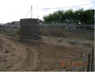
The UCSB Hollister Earthquake Observatory