Summary of Research Highlights
The global expansion of ICS research over the past few years has stimulated increasingly diverse, multi-disciplinary research. This has generated a new vibrancy in ICS and expanded the research and outreach horizons of our institute. Today, ICS projects are being conducted on every continent, graduate and undergraduate students are traveling to the Himalaya, New Zealand, and Antarctica to undertake thesis projects, and ICS scientists are collaborating with an expanding array of scientists and educators in foreign and domestic research sites.
Industrial consortia represent a new approach to supporting innovative research at ICS. Under Dr. Ben Kneller's guidance, an integrated program, consisting of a cluster of associated research projects with a variety of oil-industry funding sources, has been initiated this past year on sedimentation in deep marine environments. Two new consortium projects based at UCSB, continuing involvement with a consortium based at the University of Leeds (UK), and several single-sponsor projects are together permitting a wide range of research in this field. Field-based geological studies of ancient deep marine sediments onshore are pioneering digital mapping techniques, based on laser range-finding and both ground- and satellite-based digital elevation models. Study areas include ancient sedimentary rocks in California, Baja California, Argentina, France, Spain, and modern systems of the Nile Delta, the Gulf of Mexico and Brunei. Three-dimensional seismic surveys from modern continental margins (with acquisition costs in the millions of dollars) provide spectacular views of geological systems rarely available to academics. Development of numerical models for sediment transport and deposition in the deep sea complement the experimental approach initially developed by the Dr. Kneller while at Leeds University and being continued through ICS. Through this collaborative program, ICS has acquired a valuable commercial 3D seismic interpretation software license, and new collaborations have emerged with UT Dallas on digital mapping techniques, with UCSB College of Engineering/ETH Zurich on numerical model development, and with Universidad Nacional de San Juan, Argentina on field studies.
For a number of years, Professor Tanya Atwater in Geological Sciences has been creating multimedia presentations of local, regional, and global geology and plate tectonics. In these projects, she has introduced geological animations into the more classic mix of landscape footage, still images, and talking heads, in order to create clear and exciting visualizations of geometrically difficult material. Her early work was supported by regular grants and production help from the U.C.S.B. Instructional Development group and by a grant from the Boyd Foundation. Many of these projects were administered through I.C.S.
The widespread educational use of her products (film, videos, CD, and Web -downloadable animations, presentations, and slides) led to her receiving the prestigious N.S.F. Director's Award for Distinguished Teaching Scholars in May 2002. With funds from this award and continued support from the Instructional Development group, Atwater has created a new center at I.C.S., the Educational Multimedia Visualization Center, or E.M.V.C. In this center, computer-savvy geoscience students work on state-of-the-art graphics computers to expand Atwater's work and to support visiting scholars who wish to create animations and multimedia projects presenting their own research projects. To view or download products of these efforts, visit http://www.geol.ucsb.edu/faculty/atwater and click "animations" in the sidebar.
This past year has been the third of the Keck Interdisciplinary Program in Seismology and Materials Physics, involving a collaboration among Professors Jean Carlson and Jim Langer in Physics, Ralph Archuleta in Geological Sciences, and Jacob Israelachvili and David Pine in Materials Science. The objective of the Keck Program is to integrate the knowledge of friction, fracture and earthquake physics at the different scales from the microscopic to the macroscopic. Postdoctoral researchers and students are the mainstay of the program. New theoretical work by Dr. Anael Lemaitre, working with Professor Carlson, builds on Langer's shear transformation zones (STZ) theory to investigate the transition from smooth sliding to stick-slip (analog for an earthquake) on lubricated surfaces subjected to a low driving shear rate. This new theory for friction is similar to the Dieterich-Ruina rate-and-state friction that is often used to describe earthquake ruptures and nucleation. Moreover, the theory yields predictions that agree with experimental results obtained by Dr. Drummond and Professor Jacob Israelachvili. Dr. Pascal Favreau and Professor Archuleta have used a dynamic earthquake rupture model to re-examine the seismic energy released during the 1979 Imperial Valley earthquake. They find that a relatively small area of the fault can account for all the seismic energy and that most of the available elastic energy that can be released is actually absorbed in the creation of the sliding surface. As a consequence, only about 20% of the total energy goes into the seismic waves that shake the ground. Eric Dunham, a graduate student working with Favreau and Carlson, has been examining how heterogeneities affect the rupture process. They find that the breaking of a high-strength region of the fault can accelerate the rupture speed to a value that exceeds the shear wave speed of the medium. Based on analysis of near-fault data from earthquakes, such rapid rupture velocities have been described for the 1979 Imperial Valley and the 1999 Izmit, Turkey, earthquakes.
The Keck program held its second international symposium on Friction, Fracture and Earthquake Physics at the Kavli Institute for Theoretical Physics on July 18 and 19, 2002. The workshop was attended by more than 40 researchers and students from universities and national laboratories.
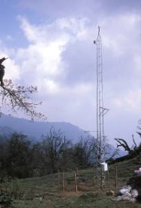
Several provocative questions have motivated another interdisciplinary project: Is it possible that the activity on faults and even the patterns of large-scale mountain building are largely determined by climate and erosion? Or, are erosion rates largely decoupled from climate and instead intimately linked to tectonic rates in rapidly deforming mountain belts? Such questions are the logical outcome of recent theoretical models suggesting that whole mountain belts will respond by deforming and faulting more quickly in places where intense precipitation localizes erosion. Over the past few years, an ICS-coordinated project has attempted to test this model in the Nepal Himalaya. One might wonder if such a project couldn't be done better closer to home, but the research team under Professor Burbank's directions thinks that Nepal is a great choice for such a "test." Because geologic and climatic data are intrinsically noisy, clear insight will only derive from a setting in which tectonic and erosion rates are high and where there are strong contrasts in climate. The Indo-Asian collision creates rapid tectonic deformation, and 8000 m of topographic relief drives intense erosion, while this same topography segregates the climate into a monsoon-drenched southern slope and a northern slope rain shadow. With initial support from NASA and now from NSF, Burbank heads a team with researchers from MIT, Harvard, Dartmouth, Washington, Wyoming, USC, Grenoble, and Nepal. They have built the most extensive and highest local network of meteorological stations across the crest of the Himalaya. At altitudes up to 4500 m, hand-built, 10-m-high weather towers have been erected in alpine settings, where they were hauled in pieces by Nepali porters. In order to measure snow fall and water content, the towers are equipped with "look-down" sensors and gamma-ray loggers to measure the snow surface and water content, respectively. These are providing the first consistent, regional measures of snow accumulation in a Himalayan setting.
|
Weather tower at 3100 m on the south side of the Annapurna Range in central Nepal. |
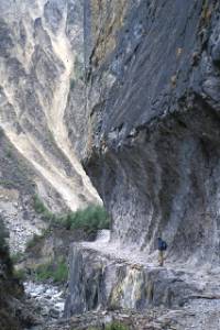
Trail cut into the bedrock gorges allow access on
foot to the high mountains. |
In fall 2002, a new suite of sensors will be installed on a glacier above 5200 m in a literally and figuratively "breath-taking" setting. The existing network has provided details of the striking impacts of orography on precipitation. Over 5 m of rain fall on the southern Himalayan slopes during the monsoon, while less than 50 cm percolates over the range crest to the north. In winter, however, snow accumulation is greater in the north than south.
To quantify past and present erosion and tectonics, researchers have established gauging stations on the rivers, installed newly designed sensors for water pressure and turbidity, calibrated glacial erosion on some key glaciers, reconstructed glacier snowlines and the timing of past advances, measured the long-term rates of river incision into the Himalayan bedrock gorges, determined where brittle and ductile deformation is or has occurred, and reconstructed the cooling and related geologic denudation history of the mountains and valleys in the study area. More than 25 Nepalis are participating in the project, receiving training on data collection, and assisting with data analysis. Their efforts to safeguard weather stations, download data from data loggers, measure river velocities and sediment loads, and coordinate research activities have been vital to the project's success to date.
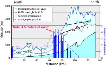
Transhimalayan topography, summer rainfall, and glacial snowlines, illustrating the profound rain shadow caused by the 8,000-m peaks and its effect on glaciers in the landscape.
Some of the striking results are that: long-term erosion rates are decoupled from climate; climatically induced pulses of sediment loading episodically overwhelm the river systems and cause even the gorges to aggrade with sediments; precipitation gradients across the range steepened during glacial ages; the Main Central Thrust (the key fault beneath the High Himalaya, but thought to be "dead" since ~10 million years ago) has been recently active; and today's glaciers are driving very little erosion, but were far more effective in the past as they carved huge valleys. In order to convey some of these results, as well as the flavor of a multi-disciplinary scientific study in rugged mountains of a developing country, Burbank's team also includes a film crew, supported through NSF, which is making a NOVA-style production both in the labs of the researchers and in the mountains of Nepal.
Dr. Kim Olsen is expanding his research on simulation and visualization of rupture dynamics and wave propagation. With French post-doc Sophie Peyrat, he is developing the first systematic non-linear inversion method to describe dynamic rupture propagation. In addition, with collaborators Mikumo and Fukuyama, he has found a method to estimate the slip-weakening distance (Dc), used in popular friction laws, directly from strong ground motion recorded in close vicinity of earthquakes on near-vertical fault planes. Together, these methods may provide important insight of the components of dynamic fracture energy, namely Dc and the dynamic strength drop, two of the most critical parameters controlling dynamic rupture. In the field of wave propagation, Olsen, together with Dr. Shapiro, has proposed an explanation for the long duration of ground motions recorded in the Mexico City Valley, which caused significant loss of life and property. He has shown that scattering at the subduction trench as well as the Mexican Volcanic Belt below the Mexico City Valley is capable of generating a significant part of the extended ground motion. In collaboration with Drs. Day and Bradley, Olsen has estimated the distribution of anelastic attenuation in the Los Angeles basin for long-period waves, an important parameter for future scenario simulations. Somewhat surprising from previous results, he finds strong attenuation in the near-surface layers, best described with the relation Qs=0.02Vs (Vs in m/s), where Qs and Vs are the S-wave attenuation factor and S-wave velocity, respectively. Finally, with UCSB graduate student Cary Marcinkovich, Olsen implemented and demonstrated the superiority of the Perfectly Matched Layers (PML) boundary conditions for 3D elastic and anelastic finite-difference wave propagation methods.
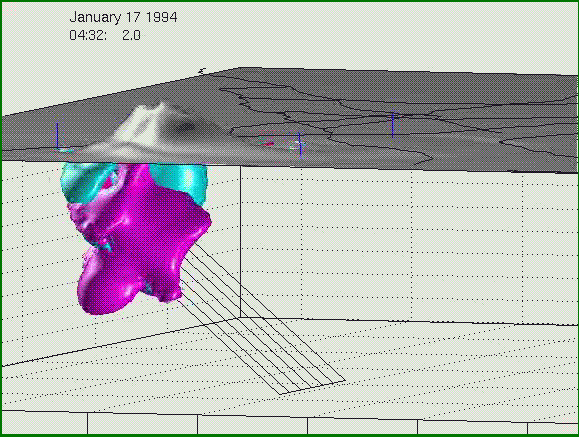
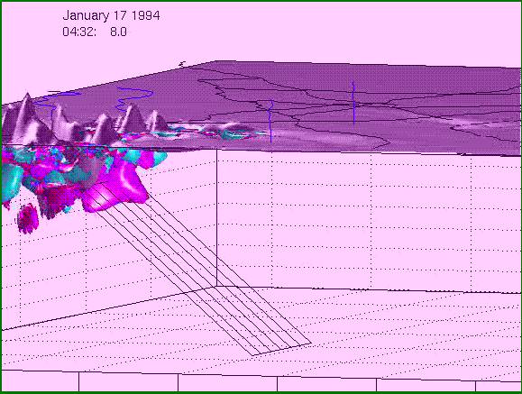
A new generation of 3D rendering of rupture and wave propagation simulations, here illustrated for the M6.7 1994 Northridge earthquake. The mesh depicts the fault plane. The NEW part of the visualization is that the entire 3D subsurface volume is rendered, rather than the motion on the ground surface as has been common practice until now. The green and red surfaces are isosurfaces for constant values of the absolute divergence and curl of the 3D velocity wavefield, representing approximations of the P and S waves propagating in and below the San Fernando Basin in the early morning hours of January 17 1994. The black lines on the surface depict major freeways in the area, and the blue lines are synthetic seismograms. The vertical component of motion (exaggerated) is superimposed on the ground surface. This way of rendering allows the viewing of interesting aspects of the wave propagation, such as the generation of larger ground motions to the north of the fault from directivity, and the entrapment of waves in the basin structure above the fault.